

Lesson 2: Place-Based Understanding of Our Environment
Grades: 3 – 5
Outcomes:
- Identify the significance of selected place names in British Columbia.
- Explain how and why people, events, and places are significant.
- Know traditional stories and the nature of the relationship between humans and their environment.
First Peoples’ Principles of Learning:
- Learning focuses on connectedness and a sense of place.
- Learning is embedded in history and story.
Brief Description: This lesson introduces students to the Sq’éwlets world, S’ólh Téméxw, by exploring their environment and the sxwōxwiyám of Mt. Cheam. Students use this knowledge to research local place names.
Sequence of Activities:
- Have students share with their elbow partner the names of different places they have visited. Does anyone know why these places are given those names?
- Introduce students to the Sq’éwlets webpage. Inform students that we are going to learn about the Sq’éwlets people by examining where they live and the names they give to places. Play the video introducing the “place where two rivers meet.” Have students refer to the regional map. Have them find where the two rivers meet.
- Locate Mt. Cheam on the regional map. Introduce students to the idea of a sxwōxwiyám (origin story). An origin story tells the history, from a specific peoples’ point of view, of how the world began. These represent a truth for that group of people. Have students share with their elbow buddy an origin story that they know of (from their own cultural history). Students may choose to share out.
- Give students blank paper and encourage them to draw images from Mt. Cheam to assist with remembering the sxwōxwiyám. Play the sxwōxwiyám for Mt. Cheam. Have elbow buddies practice retelling the story of Mt. Cheam using their pictures to assist them. Have them share: what are key features of Mt. Cheam? You may choose to locate Mt. Cheam using Google Earth to examine it from multiple perspectives. What do you notice about Mt. Cheam (shape of the mountain, direction it is facing, covered with snow, etc).
- Take students to the sxwōxwiyám places map. Demonstrate how to locate the different places and click on the voice threads to hear the names of cultural places. Connect to why each location has the name it has. Note the connection to features in the environment.
- Assessment: Individually or in pairs, assign students one of the locations on the places map. Have them locate the area on Google Earth and create a poster or diorama of the natural features of that area. Practice saying the sxwōxwiyám name correctly. You may reference the Language Resources page to assist with understanding the sound and spelling of the place name.
- Have students present out about their location, either in small groups or for the whole class.
- Finish the lesson by having students reflect on where they live…where could the find information on how that location was named?
Possible Extensions: (1) Have students research their home location (or a location of their choice). Where did the name come from? What are features of the land? Create a poster or diorama to share with classmates. (2) Take students to the logo page for this website. Watch the video and discuss how the logo was chosen to represent this Sq’éwlets project (e.g., sturgeon are an important resource for the Sq’éwlets people, sturgeon existed in the past and still today, etc). Have students create a logo for their assigned location. It should connect to the natural features of that area. Try to have students incorporate some aspects of Coast Salish art.
 Lesson 1:
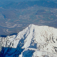 Lesson 2:
 Lesson 3:
 Lesson 4:
 Lesson 5:
 Lesson 6: